
Dwight’s Point River Camping Weekend Paddle Itinerary
Exploring the St. Louis River Estuary National Water Trail
Activity: River Camping Weekend
Route: Paddle to Dwights Point with options to explore surrounding bays and trails
Launch Point: Closest landing would be Woodstock Bay Landing, Billings Park or Arrowhead Boat Ramp are also near by.
SLRE NWT Route: Superior Bays or Clough Island Circuit (Panel D)
Time: 2–3 days
Experience Level: Intermediate to Advanced (comfortable with open water and overnight camping)
Trip Highlights: Primitive camping, fire-side relaxation, hiking, paddling, birding, stunning estuary views, sunrise and sunset over the water
Notes:
Wisconsin requires a parking permit for boats, canoe, and kayak trailers.
Share your photos with us using #SLRENWT.
Pack in, pack out. Please practice Leave No Trace principles!
Overview
Experience a summer or fall weekend immersed in the natural beauty of the St. Louis River Estuary National Water Trail (SLRE NWT) with a camping adventure at Dwight’s Point. Dwight’s Point is a free, primitive, water-accessible campsite in Superior, Wisconsin, nestled on the St. Louis River Estuary. With four tent spots, a firepit, latrine, and grill, it’s perfect for paddlers seeking a rustic weekend getaway. It’s first come, first serve, so plan accordingly.

This is Panel D of the St. Louis River Estuary National Water Trail Map. In the below itinerary, we suggest starting at Woodstock Bay Landing for closest access to Dwight’s Point Primitive Campsite. If you’d like a longer adventure, you can start in Duluth at Munger Landing and come up the east side of Clough Island. The adventure is yours to have!

Dwight’s Point Primitive Campsite.

Day paddlers enjoying lunch at a fire pit on Dwight’s Point.
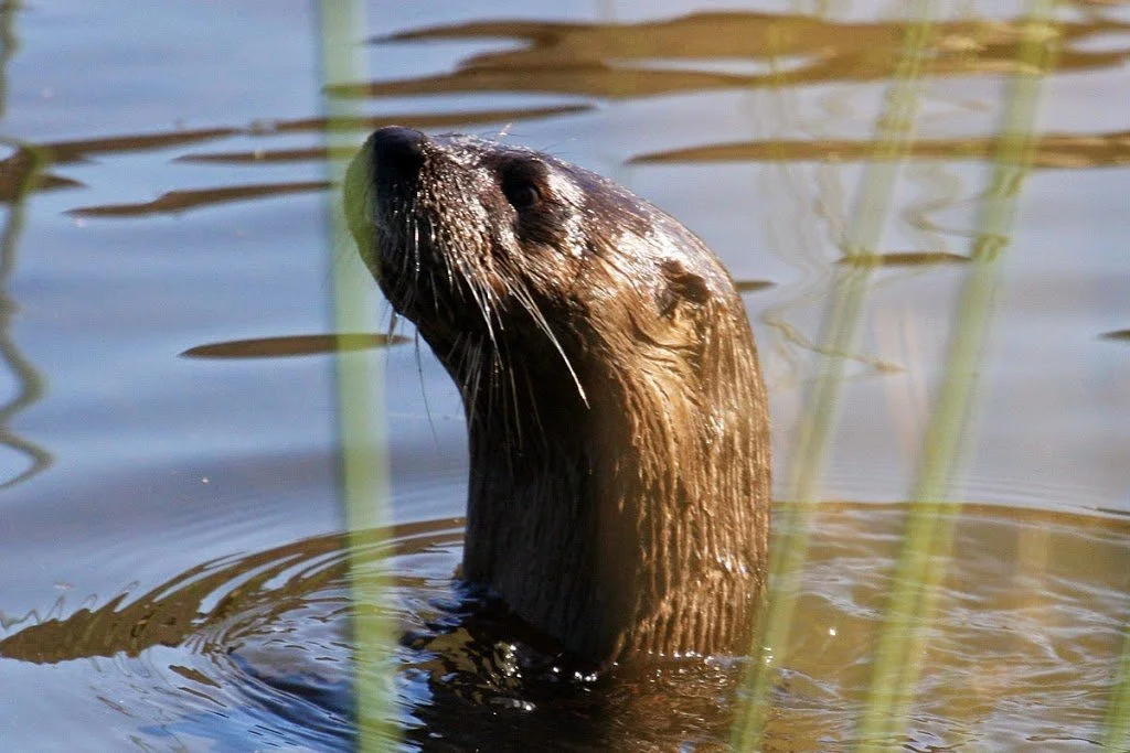
Otter sightings are common on the St. Louis River Estuary National Water Trail, be sure to give them space! If they have pups around they can become protective. Photo credit: Michael Anderson.
Itinerary
There are many launch points to choose from! If you’re looking for the most direct route, start at Woodstock Bay Landing in Superior, Wisconsin (with Billings Park or Arrowhead Public Boat Ramp as runner-ups). If you’re up for a longer paddle, you can start at Munger Landing and explore the southern banks of Clough Island as you head north through the narrow channel to Dwight’s Point.
Day 1: Arrival & Camp Setup
Paddle safely to Dwight’s Point and pull watercraft ashore.
Set up your tent on one of the four padded tent spots.
Orient yourself on the peninsula and take a short hike to enjoy the estuary scenery.
Day 2: Adventure & Exploration
Morning: Sunrise paddle or birdwatching around the St. Lous River Estuary National Water Trail. Share your photos with us using #SLRENWT.
Midday: Paddle to Spirit Lake Marina for Shipyard Smoked BBQ (weekends only, check operating times). Enjoy wings, ribs, sides, and sometimes live music.
Afternoon: Hike through the Superior Municipal Forest, the nation’s third-largest municipal forest, heading to the Superior Municipal Forest Disc Golf Course. Optionally, visit Woodstock Bay or Billings Park for exploration and lunch.
Evening: Sunset paddle, campfire cooking, reading, sketching, or writing from your campsite.
Day 3: Wrap-Up & Departure
Enjoy a morning paddle or quiet reflection on the estuary.
Pack up camp and ensure all gear is removed. Please practice Leave No Trace principles!
Paddle back to your launch point or hike out to the parking area if accessing by land.
Weekend Ideas & Activities at Dwights Point
Hiking inland to the Superior Municipal Forest Disc Golf Course
Paddle to Spirit Lake Marina for local BBQ
Hike Dwights Point peninsula or nearby municipal forest
Girl Scout Point hike
Sunrise/sunset paddling
Birdwatching and wildlife spotting
Relaxing at camp: reading, sketching, writing, or cooking
Notes & Safety
No matter which route you select, please keep in mind that winds can create choppy conditions in open bays.
Dwights Point is a primitive, free camping site accessible by water or a 2.5-mile land hike. Trails are mowed but may be wet depending on conditions.
Parking (land access): Superior Municipal Forest Disc Golf Course – 46°41'31.3"N 92°08'37.5"W
Parking (paddling access): Check local SLRE NWT public launch sites.
Primitive amenities include latrine, firepit, grill, and four padded tent spots.
The St. Louis River Alliance developed this itinerary using Federal funds under award NA24NOSX419C0020 from the Coastal Zone Management Act of 1972, as amended, administered by the Office for Coastal Management, National Oceanic and Atmospheric Administration (NOAA), U.S. Department of Commerce provided to the Minnesota Department of Natural Resources (DNR) for Minnesota’s Lake Superior Coastal Program.