
Restoring Wetland Habitat in Allouez Bay: Phase 2 Restoration Update
Provided by Molly Wick, Wisconsin Department of Natural Resources (WDNR)
The WDNR is working with the US Army Corps of Engineers (USACE) along with many partners to evaluate the possibility of creating features in the eastern portion of Allouez Bay to help reduce wave energy and protect high quality wetland habitat.
Historically, eastern Allouez Bay supported more extensive wetlands than are present today. Rapid water level fluctuations, changes to the harbor, and other stressors have increased the exposure of these wetlands to high wave and wind energy. Over time, this exposure has significantly reducing the existing wetland in the bay. For additional background on this effort, see Allouez Bay Phase 2.
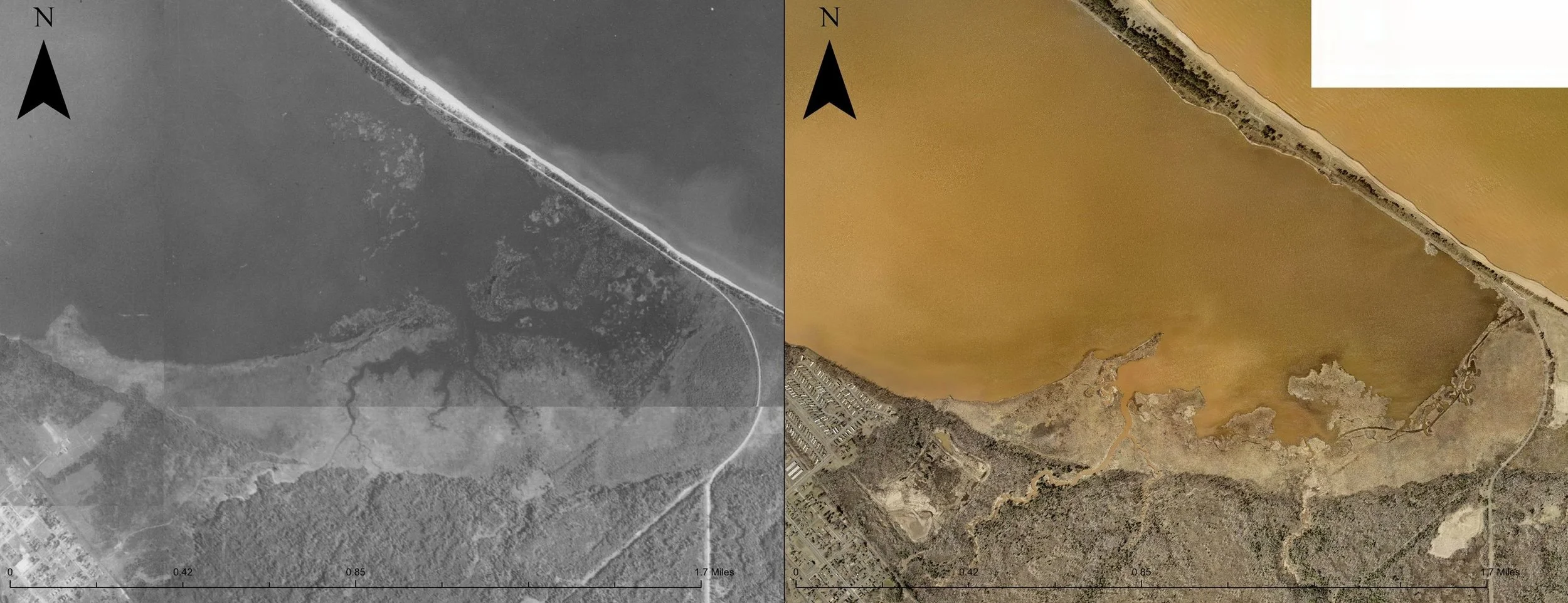
Figure 1. A side by side comparison of the Allouez Bay wetland complex with historic aerial imagery captured in 1938 (left) and modern high resolution Ortho imagery captured 2025 (right). Source of imagery: City of Superior Online Geospatial Imagery catalog https://www.superiorwi.gov/618/Imagery
Figure 2. A transparent overlay comparison of the Allouez Bay wetland complex with historic aerial imagery captured in 1938 (transparent) overlayed modern high resolution Ortho imagery captured 2025 (base layer). The current extent of the wetland complex is highlighted in green (Polygon source: Schwarting, R., K. Beaster, A. Eliot, 2021. Implementing invasive species management in coastal wetlands along Lake Superior. University of Wisconsin-Superior Report.)
Exploring Options to Reduce Wave Energy
WDNR and USACE have worked together to identify possible features that could be constructed to help create more sheltered conditions in the eastern portion of the bay. These features are intended to reduce wave energy and support the recovery of emergent vegetation, which in turn would:
Provide habitat for a variety of bird species, including breeding marsh birds
Support fish spawning and foraging
Improve coastal wetland resiliency
Offer recreational benefits
Through conversations with residents, site users, and anglers, WDNR heard strong support for maintaining the main portion of the bay as it is currently enjoyed for fishing. In response, restoration planning is focused exclusively on the easternmost portion of Allouez Bay, outside of the primary fishing area.
Using Modeling to Guide Design
USACE has developed a wave model for Allouez Bay that reproduces existing conditions. This model is being used to test different feature configurations to determine which layouts most effectively reduce wave energy and create sheltered conditions.
The figure below illustrates the second alternative evaluated with the model. This alternative includes several island features designed to work together to shelter the eastern bay from northwesterly winds, which build wave energy across the length of Superior Bay. The variety of island sizes and shapes is intended to create a mosaic of habitat types.
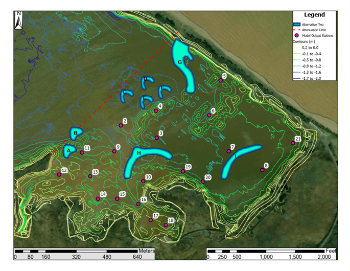
Figure caption: Alternative 2 consists of nine features, including a peninsula off of Wisconsin Point, two long narrow islands, and several smaller islands that work in concert to break wave energy. These features would likely be designed to be islands rising just above the water surface at most normal water levels. Features are focused to the southeast of the red dashed line, to stay out of the main fishing area.
Although detailed technical specifications will be developed later, the project may offer opportunities to beneficially reuse dredged material from the harbor. Reuse of dredge material is a priority, as there are limited options for long-term storage.
What’s Next?
The technical and partner teams are currently reviewing the results of the model for Alternative 2 and developing a third alternative to evaluate with the model. The third alternative will build on what we learned from the first two alternatives and will inform a conceptual design that will outline the recommended features. These versions of possible designs have not yet been fully evaluated or permitted, so changes are likely as the project moves forward. If you have feedback or thoughts on these plans, reach out to the project manager below.
Later this year, USACE will publish a technical memo that describes a final recommended conceptual design based on the modeled alternatives. WDNR will then seek funding to move forward with technical design and eventually implementation in the coming years. Stay tuned for future updates!
This project is funded by the Great Lakes Restoration Initiative. Many partners are involved in the process, including Audubon Great Lakes, Fond du Lac Band of Lake Superior Chippewa , Minnesota Land Trust, University of Wisconsin Superior, University of Minnesota Natural Resources Research Institute, St. Croix Band of Lake Superior Chippewa, Lake Superior National Estuarine Research Reserve, and US EPA Office of Research and Development.
Contact project lead: Molly Wick, Wisconsin DNR at Molly.wick@wisconsin.gov or 715-817-8510
Interested in Project Updates?
Sign up for the St. Louis River Alliance’s Newsletter: stlouisriver.org/enewsletter